

Exploration Targets · Beyond the Resource
Nearly two decades of drilling and fieldwork at Thor now inform a wider exploration campaign across the consolidated Silver Cup Mining District.
Exploring the wider system
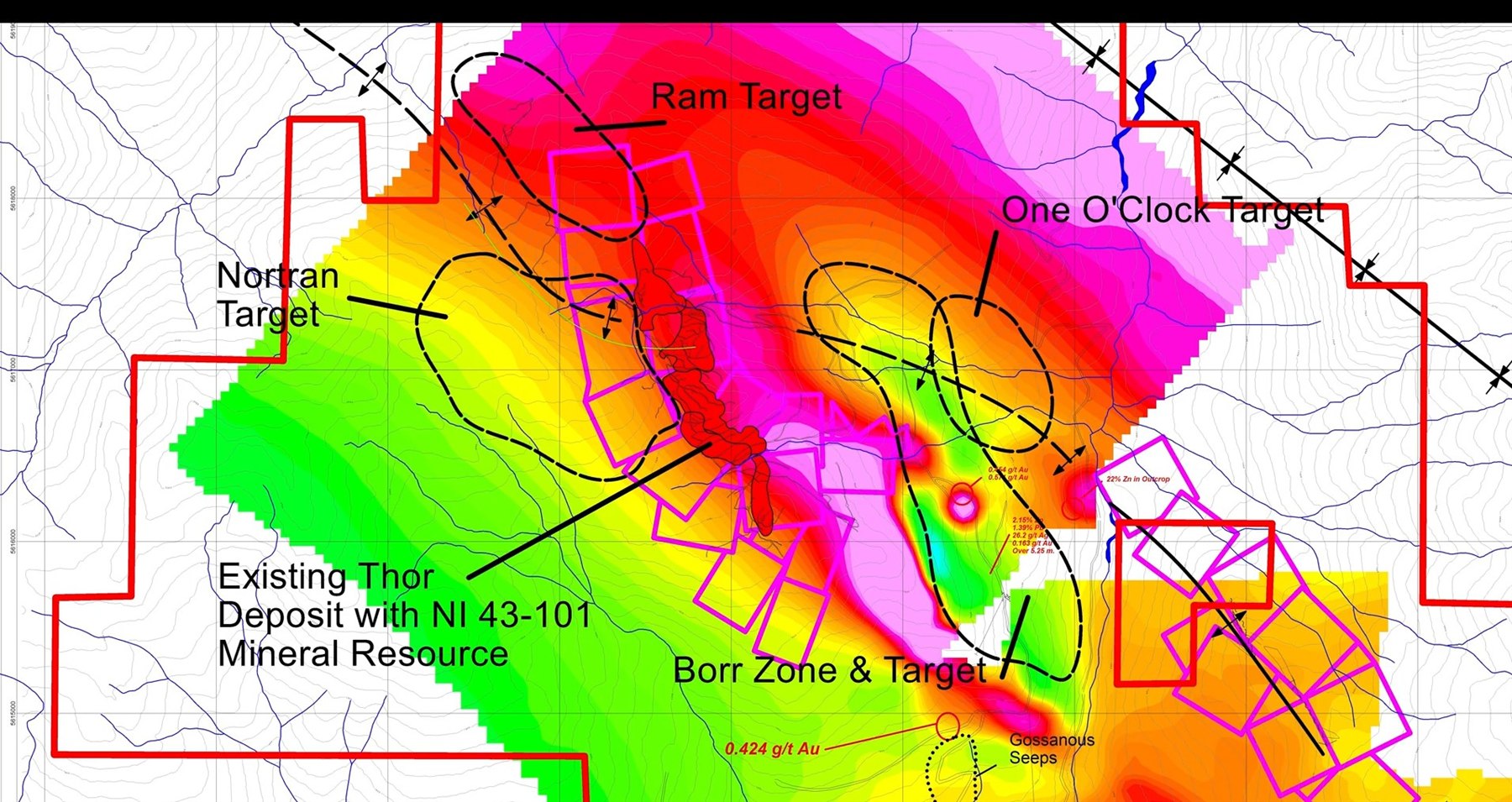
The near-surface Thor deposit provides a detailed geological reference point. Taranis is applying that knowledge to targets lateral to and beneath the classified Mineral Resource.
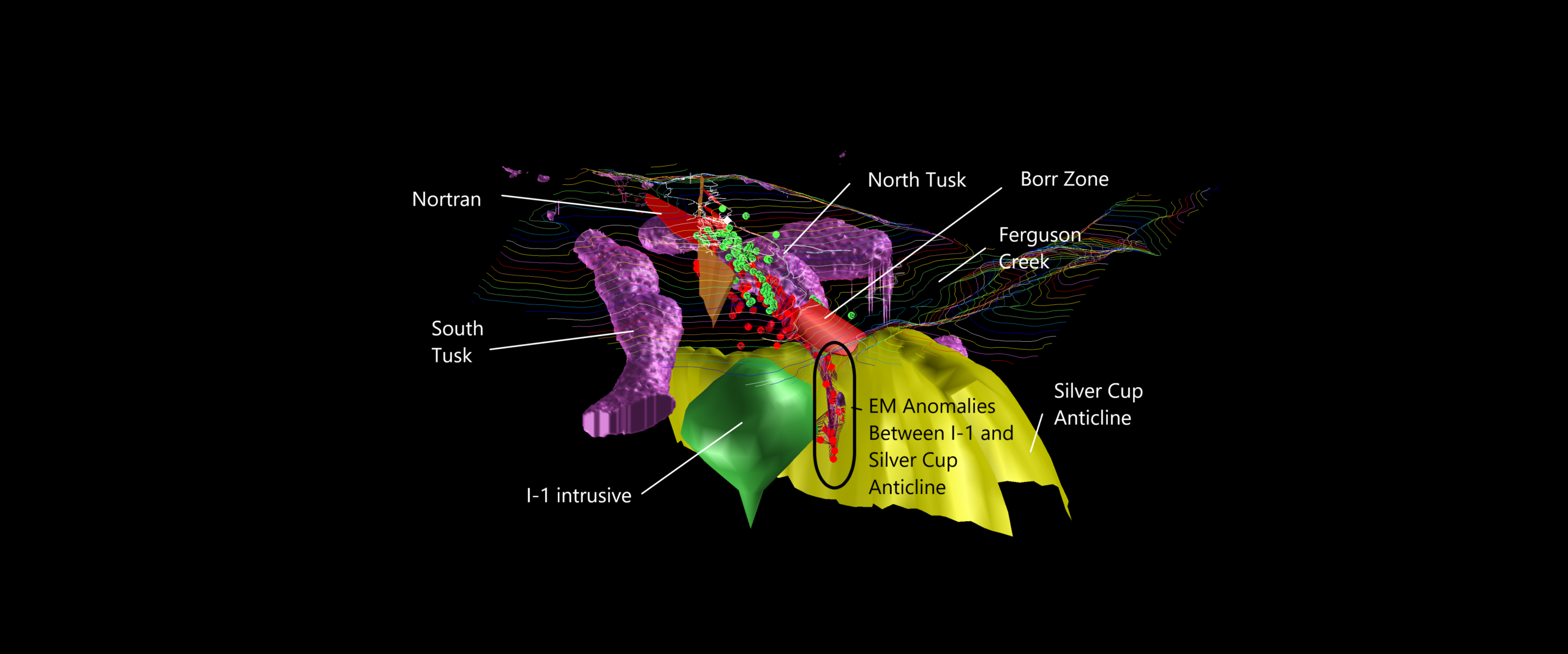
The working model interprets Thor as the upper-level expression—the “Trunk”—of a much larger magmatic-hydrothermal system. Deep geophysics identifies the conceptual intrusive “Elephant” and alteration “Tusks,” while structural work defines opportunities along the broader Silver Cup Anticline.
Each target presents a different geological question. Target dimensions and comparisons describe exploration concepts, not Mineral Resources or estimates of contained metal.
 Expand target map
Down-dip continuation
A drill-confirmed occurrence east of the lamprophyre dyke, testing whether the Thor epithermal system continues down-slope toward the Silver Cup Anticline.
The geological thesis
Three-dimensional modelling indicates that a younger, steeply dipping lamprophyre dyke cuts the original epithermal system. The Borr Zone is interpreted as mineralization displaced to the east and down-dip of the main Thor deposit.
The interpretation would connect the otherwise “rootless” near-surface Thor mineralization toward the plunging Silver Cup Anticline. Additional drilling is required to establish geometry and continuity.
 ▶Technical analysis
Official YouTube ID required
5.25 m grading 26.2 g/t silver, 0.163 g/t gold and 3.55% combined lead and zinc.
Pyrite, sphalerite, galena and tetrahedrite within strongly altered metasedimentary rocks.
The prospective trend extends well beyond the discovery intercept and provides a corridor for follow-up work.
If contiguous, the modelled Borr exploration area is approximately five times the footprint of the existing Thor deposit.
Target caution: The five-times comparison relates to conceptual exploration area, not tonnage, grade, economic value or a Mineral Resource.
Fault-displaced extension
The former Western Deeps target tests whether the missing western portion of Thor was displaced downward across the Ripper Fault into the Horton Area.
The geological thesis
Mapping completed in 2022 identified the northwest-trending, near-vertical Ripper Fault along the western margin of the lamprophyre dyke. The working interpretation is that this structure truncated Thor and down-dropped part of the system into the parallel Horton valley.
The boulder field, terrain position and clusters of conductive anomalies provide independent evidence for an undiscovered bedrock source west of the known deposit.
 ▶Technical analysis
Official YouTube ID required
A train of mineralized float ranges from small boulders to car-sized blocks across the Horton Area.
Selected boulders reportedly returned values up to 14.55 g/t gold and 1,705 g/t silver.
LiDAR indicates the boulders could not have travelled downhill from the existing Thor deposit.
Irregular conductive responses provide multiple discrete areas for follow-up beneath cover.
Sampling caution: Float-boulder assays are selective samples and may not represent the grade or continuity of an undiscovered bedrock source.
Deep magmatic connection
A conceptual deep target at the interpreted junction between the I-1 resistive feature and the plunging Silver Cup Anticline.
The geological thesis
In a linked porphyry-epithermal model, distal precious-metal veins may be sourced from a deeper intrusive system. One O'Clock occupies the northeast contact area between the interpreted I-1 body and the anticlinal structure that controls much of the district's historic mineralization.
The target is visible through integrated deep-penetrating MobileMT inversion rather than surface exposure. Its geological nature can only be determined through additional work and drilling.
 ▶Technical analysis
Official YouTube ID required
A circular resistivity high interpreted from the airborne MobileMT dataset.
A conductive envelope—the conceptual “Tusks”—surrounds the resistive feature.
The target occupies a modelled junction with the plunging Silver Cup Anticline.
Peripheral drilling intersected monzodiorite dykes and propylitic contact-metamorphic alteration.
 Expand 3D model
Northern frontier
A concealed northern continuation target extending beyond Thunder and beneath post-mineral landslide debris on Thor's Ridge.
The geological thesis
Historic exploration stopped where prospective bedrock disappeared beneath extensive slide material. Modern LiDAR reveals the scale of this younger cover and allows old soil and till datasets to be reinterpreted in their proper terrain context.
The Thunder discovery provides an analogue: high-grade epithermal mineralization was found beneath slide cover on the southern flank of Thor's Ridge. Ram applies that exploration model farther north.
 ▶Technical analysis
Official YouTube ID required
Public Westmin and Ram Explorations soil and till data have been compiled and digitized.
A reported till sample at the slide toe returned a highly anomalous silver value; multiple soils returned 5–7 g/t silver.
The 2021 discovery demonstrates that mineralization can be preserved beneath rockslide cover.
Successful drilling could test whether the epithermal trend extends northward beyond the current deposit.
Geochemical caution: Historic soil and till results are exploration indicators. They do not demonstrate the grade, thickness or continuity of mineralization in bedrock.
Unlock the district
Review the classified Mineral Resource, the bulk-sample program and current corporate materials alongside the district-scale exploration thesis.
Exploration targets are conceptual in nature. There has been insufficient exploration to define a Mineral Resource at Borr, Nortran, One O'Clock or Ram, and it is uncertain whether further exploration will result in a Mineral Resource.